Negotiation.gr | Strategic Wisdom for the Technological Age
Abstract
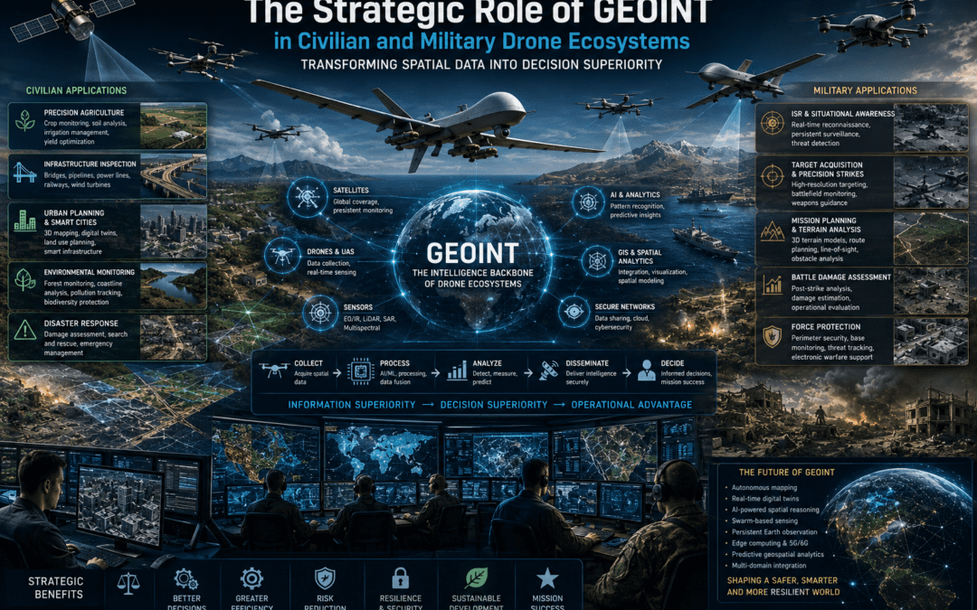
Geospatial Intelligence (GEOINT) has emerged as one of the most strategically important capabilities of the twenty-first century. While drones have dramatically expanded the ability to collect imagery and spatial information, their true value lies in transforming raw data into actionable intelligence. Today, GEOINT integrates remote sensing, Geographic Information Systems (GIS), Artificial Intelligence, satellite communications, cloud computing, digital mapping, and advanced analytics into comprehensive technology ecosystems that support informed decision-making. This thesis argues that GEOINT has become the strategic backbone of both civilian and military drone ecosystems, enabling innovation, operational effectiveness, resilience, and strategic advantage across an increasingly interconnected world.
Introduction
The evolution of unmanned aerial systems has transformed the way humanity observes, understands, and manages the physical environment.
Modern drones can collect enormous quantities of spatial information.
High-resolution imagery.
Thermal data.
LiDAR point clouds.
Synthetic Aperture Radar.
Multispectral observations.
Three-dimensional terrain models.
However, collecting information is only the beginning.
The true strategic value emerges when that information is interpreted, integrated, and transformed into knowledge that supports better decisions.
This transformation defines the role of Geospatial Intelligence.
GEOINT: From Geography to Strategic Intelligence
Geospatial Intelligence extends far beyond traditional mapping.
It combines:
- Geographic Information Systems (GIS),
- Earth observation,
- satellite imagery,
- drone imagery,
- remote sensing,
- Artificial Intelligence,
- spatial databases,
- digital terrain analysis,
- predictive analytics.
Rather than asking only “Where?”, GEOINT also answers:
- What is happening?
- Why is it happening?
- What may happen next?
- How should decision-makers respond?
Geography becomes strategic intelligence.
GEOINT in Civilian Drone Ecosystems
Civilian drone applications increasingly rely on GEOINT to create measurable value.
In agriculture, drones monitor crop health, irrigation efficiency, pest outbreaks, and soil variability.
Infrastructure operators inspect bridges, railways, pipelines, wind farms, and electrical networks with high spatial accuracy.
Urban planners develop digital twins supporting smart-city planning and sustainable development.
Environmental agencies monitor forests, coastlines, biodiversity, pollution, and climate impacts.
Emergency responders rapidly assess damage following earthquakes, floods, and wildfires.
Across all these applications, the drone functions primarily as the information collection platform.
GEOINT transforms that information into operational knowledge.
Artificial Intelligence and Spatial Intelligence
Artificial Intelligence has become a powerful force multiplier for GEOINT.
AI enables:
- automated object recognition,
- infrastructure anomaly detection,
- change detection,
- terrain classification,
- predictive maintenance,
- image segmentation,
- traffic analysis,
- pattern recognition.
Instead of replacing analysts, AI accelerates analysis, allowing experts to focus on interpretation, strategic assessment, and decision-making.
The relationship between AI and GEOINT illustrates how technology ecosystems amplify human expertise.
Digital Twins and Smart Infrastructure
One of GEOINT’s most transformative civilian applications is the creation of digital twins.
Drone-generated geospatial data enables highly accurate digital representations of:
- cities,
- ports,
- airports,
- industrial facilities,
- transportation corridors,
- energy infrastructure.
These digital environments improve planning, maintenance, risk management, resilience, and investment decisions.
The future of smart infrastructure increasingly depends upon continuously updated geospatial intelligence.
GEOINT in Military Drone Ecosystems
Military organizations increasingly consider GEOINT indispensable.
Modern drone operations support:
- Intelligence, Surveillance and Reconnaissance (ISR),
- target identification,
- route planning,
- force protection,
- logistics,
- mission planning,
- battle damage assessment,
- operational monitoring.
By integrating drone imagery with satellite intelligence, terrain databases, and Artificial Intelligence, commanders gain a comprehensive understanding of the operational environment before, during, and after military operations.
GEOINT and Network-Centric Warfare
Network-centric warfare depends upon shared information.
Within this environment, GEOINT serves as the common spatial framework connecting:
- drones,
- satellites,
- command centers,
- intelligence analysts,
- ground forces,
- naval units,
- air assets.
Every participant operates from the same geospatial understanding.
This shared operational picture accelerates coordination, reduces uncertainty, and enhances decision superiority.
Decision Superiority
The modern battlefield increasingly rewards those who make better decisions faster.
GEOINT contributes directly to this objective by providing accurate, timely, and continuously updated spatial intelligence.
Commanders no longer rely solely on static maps.
They operate within dynamic digital environments that evolve in real time.
Decision superiority therefore becomes a function of information quality rather than information quantity alone.
GEOINT as a Technology Ecosystem
Modern GEOINT represents an interconnected technology ecosystem.
It integrates:
- drones,
- satellites,
- Geographic Information Systems,
- Artificial Intelligence,
- cloud computing,
- cybersecurity,
- communications networks,
- remote sensing,
- spatial analytics,
- software engineering,
- human expertise.
No single technology generates geospatial intelligence.
Its value emerges through the interaction of the entire ecosystem.
Human Expertise
Despite extraordinary technological progress, GEOINT remains fundamentally human-centered.
Engineers develop systems.
Pilots collect information.
Analysts interpret patterns.
Decision-makers establish priorities.
Artificial Intelligence accelerates processing.
Human judgment transforms information into wisdom.
Technology supports.
People decide.
Looking Toward the Future
The next generation of GEOINT will likely include:
- autonomous mapping,
- AI-assisted spatial reasoning,
- persistent Earth observation,
- real-time digital twins,
- swarm-based sensing,
- edge computing,
- predictive geospatial analytics,
- multidomain information fusion.
GEOINT will increasingly evolve from describing the present to anticipating future developments.
The strategic importance of Geospatial Intelligence extends far beyond the production of maps or imagery. GEOINT has become the intelligence backbone of modern civilian and military drone ecosystems, transforming spatial information into actionable knowledge that supports innovation, resilience, security, and sustainable development.
In civilian sectors, GEOINT enables smarter agriculture, safer infrastructure, more resilient cities, and more effective disaster response.
In military operations, it enhances situational awareness, operational planning, multidomain coordination, and decision superiority.
As Artificial Intelligence, autonomous systems, cloud computing, and advanced remote sensing continue to evolve, GEOINT will become an increasingly central component of global technology ecosystems.
Ultimately, the strategic advantage of the twenty-first century will belong not simply to those who collect the most geospatial data, but to those who most effectively transform spatial information into informed decisions, resilient systems, and responsible action.
In the emerging technological era, GEOINT is no longer merely a tool of observation—it is becoming one of the principal foundations of strategic intelligence.
Source: Open Sources Analysis, Relative Data Analysis by Nikos Chatzis
© Nikolaos Chatzis. The Techne–Phronesis Negotiation Framework™
Technology Creates Capability • Systems Thinking Creates Understanding • Strategic Wisdom Creates Lasting Value.
Negotiation.gr | Strategic Wisdom for the Technological Age